Johns Hopkins UniversityEst. 1876
America’s First Research University
March 1, 2022 by Elena Conway
John Greene traces the start of his collection of 2,000 maps to 1978, when he wandered into a map store while accompanying his wife Linda on a business trip to London.
“I was just blown away with the antiquity and the information,” he says, remembering his purchase that day of a 1690s map of Maryland and Virginia.
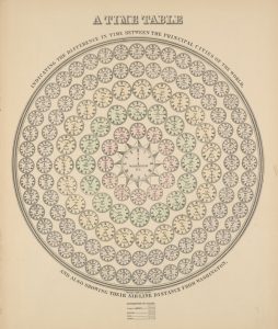
For the next 40 years, he kept an eye out for antique stores and auction listings advertising maps to add to his growing collection. He focused on different subjects over time, including instances where cartographers had an incorrect understanding of the area — the collection has 25 maps spanning a century showing California as an island — or of thematic maps, which portray the geographic patterns of invisible subject matters, similar to modern visualizations of the geographical distribution of COVID-19 cases in Maryland. While he collected a few late 19th century maps of Annapolis, where he calls home, most of the collection can be dated from the 1830s all the way back to the 1500s.
By 2020, Greene was finding opportunities to purchase maps about 30 times a year and began to think about the future of his collection. He and Linda agreed that the maps should stay together rather than sold individually and used by people who could take advantage of the information they provide.
Of the possible recipients they researched in Maryland, the Greenes were impressed by the responsiveness and interest expressed by the Sheridan Libraries team, not to mention their management of similar collections, such as the Hackerman Map Collection. Therefore, without any prior affiliation to Johns Hopkins, in 2021 they donated the maps to form the John and Linda Greene Map Collection.
Lena Denis, A&S ’11 — the geospatial data, geographic information systems (GIS), and maps librarian in the data services department — says Greene was participating in a long and important tradition of map collecting.
“Historically, maps were treated as a means to an end,” she explains. “They were cutting-edge pieces of information, and have a very long history of being used as news-pamphlets that could be understood even by those who were illiterate.”
Denis says that for this reason, universities like Johns Hopkins traditionally collected maps as they were being made with the latest information, particularly as professors worked with governments during wartimes. This means that most university collections are overrepresented with late 19th to mid-20th century maps, unlike in private collections, which can focus on aesthetics or historical significance.
“John was collecting all over the world, not only maps of Maryland and Baltimore, but things he found compelling with a very global span,” Denis says. “His collection is very historic and incredible, going back even into the 16th century. It lends to even more research interests that are currently relevant for us.”
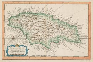
Cataloguing and digitizing a collection of this size takes “an army,” Denis says. But thanks in part to the tech services department, the maps catalogued thus far are already supporting the research of economics and international studies major Julia Mendes, a 2021-2022 participant in Special Collections Freshman Fellows — a program designed to introduce first-year students to research with rare primary source materials. By studying the collection’s early maps of the Americas, Mendes is tracking changes to the Caribbean over the centuries, from the erasure of native place names to shoreline erosion due to climate change.
“Working with the collection has been absolutely amazing. The maps tell some of the most interesting stories in recent human history,” says Mendes, whose interest in the subject stemmed from geography research work she conducted in the Caribbean in high school. “This opportunity has been a massively important part of my first semester here at Hopkins. I feel like it gave me a lot of direction, but also helped remind me of the academic interests I have outside of the majors I study.”
Denis adds, “The work she’s doing is a librarian’s dream. We like to do research ourselves, but it’s really satisfying to see other people get to do things because of the work we’ve put in.”
John and Linda Greene, who share a passion for education, also look forward to seeing what Hopkins researchers discover through the collection.
“This collection is a labor of love, and it would have been a real loss to break it up by selling it. I really wanted to leave something that could be beneficial for others in the future, and by giving these maps to Johns Hopkins, I’m comfortable that that’s what’s going to happen,” John Greene says. “Even if only 10 people ultimately use them, that’s still 10 people who are able to find the answers they were looking for about the world because of my collection.”
View some of the maps from the John and Linda Greene Maps Collection that have been digitized.
Topics: Alumni, Faculty and Staff, Sheridan Libraries and University Museums, Fuel Discovery